Benefit
Longitudinal sections visualize important details in the vicinity of pipelines and nodes that are difficult or impossible to find on the site plan or overview plan. This includes :
hydraulically correct planning of gravity sewers
vertical references of sewers in the separation system
vertical position of connections and lines of other media (crossing lines)
course of terrain, water level and pressure lines
compliance with the minimum cover
Longitudinal sections are generated directly from the database as a projection of the elements onto the connecting axis between network nodes. The results of network planning can therefore be checked immediately on the longitudinal section.
Functionality
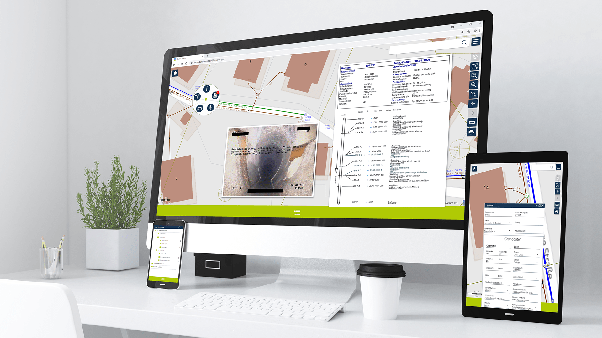
selection of the pipe sections via the network logic (tree structure), navigation in and against the flow direction possible alternative selection of the reaches in BaSYS-Plan For the purpose of uniform distance between representation and legend, line sections with reasonable reference heights can be defined in case of large bottom gradients.
This could be your solution? Send us a message and we will get back to you:
SQL queries can be used to access any data in the database. This enables, for example, the display of terrain lines and water level positions.
Individual layout of all longitudinal section elements including legends. Storage of all layouts in the library. Thus fast assignment, copying and adjustment possibilities.
Clearly arranged hierarchy Drawings >> Longitudinal Sections >> Strand Sections. Thus intuitive fast navigation.
Benefit
Longitudinal sections visualize important details in the vicinity of pipelines and nodes that are difficult or impossible to find on the site plan or overview plan. This includes
hydraulically correct planning of gravity sewers
vertical references of sewers in the separation system
vertical position of connections and lines of other media (crossing lines)
course of terrain, water level and pressure lines
compliance with the minimum cover
Longitudinal sections are generated directly from the database as a projection of the elements onto the connecting axis between network nodes. The results of network planning can therefore be checked immediately on the longitudinal section.
Functionality
selection of the pipe sections via the network logic (tree structure), navigation in and against the flow direction possible
alternative selection of the reaches in BaSYS-Plan
For the purpose of uniform distance between representation and legend, line sections with reasonable reference heights can be defined in case of large bottom gradients.
SQL queries can be used to access any data in the database. This enables, for example, the display of terrain lines and water level positions.
Individual layout of all longitudinal section elements including legends. Storage of all layouts in the library. Thus fast assignment, copying and adjustment possibilities.
Clearly arranged hierarchy Drawings >> Longitudinal Sections >> Strand Sections. Thus intuitive fast navigation.


BaSYS Lila
Benefit
Longitudinal sections visualize important details in the vicinity of pipelines and nodes that are difficult or impossible to find on the site plan or overview plan. This includes :
hydraulically correct planning of gravity sewers
vertical references of sewers in the separation system
vertical position of connections and lines of other media (crossing lines)
course of terrain, water level and pressure lines
compliance with the minimum cover
Longitudinal sections are generated directly from the database as a projection of the elements onto the connecting axis between network nodes. The results of network planning can therefore be checked immediately on the longitudinal section.
Functionality
selection of the pipe sections via the network logic (tree structure), navigation in and against the flow direction possible alternative selection of the reaches in BaSYS-Plan For the purpose of uniform distance between representation and legend, line sections with reasonable reference heights can be defined in case of large bottom gradients.
This could be your solution? Send us a message and we will get back to you:
SQL queries can be used to access any data in the database. This enables, for example, the display of terrain lines and water level positions.
Individual layout of all longitudinal section elements including legends. Storage of all layouts in the library. Thus fast assignment, copying and adjustment possibilities.
Clearly arranged hierarchy Drawings >> Longitudinal Sections >> Strand Sections. Thus intuitive fast navigation.
Benefit
Longitudinal sections visualize important details in the vicinity of pipelines and nodes that are difficult or impossible to find on the site plan or overview plan. This includes
hydraulically correct planning of gravity sewers
vertical references of sewers in the separation system
vertical position of connections and lines of other media (crossing lines)
course of terrain, water level and pressure lines
compliance with the minimum cover
Longitudinal sections are generated directly from the database as a projection of the elements onto the connecting axis between network nodes. The results of network planning can therefore be checked immediately on the longitudinal section.
Functionality
selection of the pipe sections via the network logic (tree structure), navigation in and against the flow direction possible
alternative selection of the reaches in BaSYS-Plan
For the purpose of uniform distance between representation and legend, line sections with reasonable reference heights can be defined in case of large bottom gradients.
SQL queries can be used to access any data in the database. This enables, for example, the display of terrain lines and water level positions.
Individual layout of all longitudinal section elements including legends. Storage of all layouts in the library. Thus fast assignment, copying and adjustment possibilities.
Clearly arranged hierarchy Drawings >> Longitudinal Sections >> Strand Sections. Thus intuitive fast navigation.
This could be your solution? Send us a message and we will get back to you: